Escalante River
The Escalante cuts 87 miles through the most remote canyon country in the Lower 48 — a wading, swimming, packraft corridor through Grand Staircase-Escalante, with Ancestral Puebloan sites in every alcove. · UT
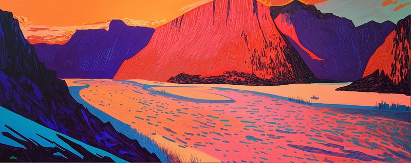
The Escalante River carves 87 miles through the most remote canyon wilderness in the contiguous United States — from the Escalante Mountains of southern Utah through Grand Staircase-Escalante National Monument to Lake Powell. It is not a raft river. It is a wading river, a swimming river, a packraft river, a canyon that you move through on the canyon’s terms: pressing through shoulder-width Navajo Sandstone slots with your pack overhead, swimming cold pools in October light, sleeping on sand beaches fifty feet above the waterline scratched there by the last flood. The Escalante has no dams, no rapids in any conventional sense, no boat ramp, and no road crossing for much of its length. What it has are walls — 300 feet of cross-bedded Jurassic sandstone dropping straight to the water — and hundreds of Ancestral Puebloan alcoves, granaries, and pictograph panels tucked into the rock above the flood line, and tributaries that themselves contain entire canyon systems: Death Hollow, Coyote Gulch, The Gulch, Harris Wash. Grand Staircase-Escalante National Monument, created in 1996, protects the full watershed. The flash flood risk is real and the terrain is serious. But for those willing to plan carefully and move at the canyon’s pace, the Escalante is one of the defining desert experiences in North America.
Signature Experiences
- Death Hollow — swimming through cold, deep pools in a tight Navajo Sandstone narrows
- Ancestral Puebloan alcove granaries and pictograph panels throughout the canyon system
- Crack-in-the-Wall — squeezing through a body-width slot in the sandstone into the lower canyon
- Coyote Gulch — the most famous tributary, with arches, bridges, and alcoves in a spectacular side canyon
- Sleeping on sand beaches 50 feet above the waterline while the canyon holds perfect silence
3 sections, 87 miles
free-flowing and intermittent — no dams exist on the Escalante mainstem; flow is driven by snowmelt from the Aquarius Plateau (spring) and monsoon rainfall (summer–fall); the river is often near-dry in late summer drought years and can flash flood dramatically from tributary cloudbursts
Escalante River near Escalante, UT
The primary USGS monitoring station on the Escalante River — located near the town of Escalante and providing the primary flow reference for upper and middle canyon sections. Due to the river's extremely low normal flows (5–30 cfs) and its flash-flood character, this gauge is used differently from most Colorado Plateau river gauges. The absolute CFS number matters less than the trend: a rising gauge on the Escalante means a flood event is in progress somewhere in the watershed and canyon travel should stop immediately.
Current flow — Escalante River near Escalante, UT
The Escalante rewards those who time it carefully. Fall (October–November) is peak season: moderate temperatures, stable weather, and the canyon lit in autumn cottonwood gold. Spring (March–April) can be excellent but snowmelt creates higher flows and cold water. Summer (June–August) is dangerous — extreme heat in the canyon bottoms (115°F+) and the highest flash flood risk from afternoon monsoon storms; summer travel in the canyon is not recommended for inexperienced parties. The flash flood hazard is the controlling variable year-round — check forecasts obsessively. Thunderstorms 30 miles away can send a wall of water through a narrows with no warning.
The Escalante canyons are carved almost entirely through the Navajo Sandstone — one of the largest ancient erg (desert dune) deposits ever formed, accumulating during the Jurassic when this region lay near the equator under vast seas of wind-driven sand. The cross-bedded faces visible in the canyon walls are the preserved face angles of ancient dune slip faces, each set recording the prevailing wind direction 180 million years ago. The river has cut 300–600 feet into this formation, creating the narrow, smooth-walled slots that define Escalante canyon character. Springs emerge along the contact between the Navajo Sandstone (permeable) and the underlying Kayenta Formation (impermeable) — creating the hanging gardens, seeps, and cottonwood-lined alcoves found throughout the canyon system.
Age range: Triassic through Jurassic
The Escalante corridor supports some of the most intact riparian hanging garden communities on the Colorado Plateau — fed by springs at the Navajo-Kayenta formation contact. These microhabitats support rare and endemic plant species not found in the surrounding desert. Desert bighorn sheep were extirpated from the Escalante drainage and reintroduced through a BLM/NPS program; the population has recovered significantly. The remote canyon sections carry extremely low visitation pressure relative to their length — ecological communities here are among the least human-impacted in the monument system.
Notable Expeditions
- Domínguez-Escalante Expedition
- Hole-in-the-Rock Expedition