Places
Parks
National parks, state parks, and the public lands that anchor the region.
National Parks — Utah
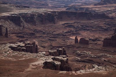
Arches National Park
- Colorado Plateau
- UT
- National Park Service
76,000 acres of sandstone arches, fins, and balanced rock north of Moab — the densest concentration on Earth.
Bryce Canyon National Park
- Colorado Plateau
- UT
- National Park Service
A rim, not a canyon: the largest concentration of hoodoos on Earth, on the edge of the Paunsaugunt Plateau.
Canyonlands National Park
- Colorado Plateau
- UT
- National Park Service
Utah's largest park, cut by the Colorado and the Green into four districts — Island in the Sky, the Needles, the Maze, and the rivers themselves.
Capitol Reef National Park
- Colorado Plateau
- UT
- National Park Service
A hundred-mile wrinkle in the crust, a Mormon orchard at its centre, and a county with no stoplights.
Zion National Park
- Colorado Plateau
- UT
- National Park Service
Utah's first national park: 2,000-foot Navajo Sandstone above the Virgin River, in a canyon the shuttle is the only way into.
National Parks — Beyond Utah
Great Basin National Park
- Great Basin
- NV
- National Park Service
The Snake Range rising out of Nevada's sagebrush ocean — Wheeler Peak at 13,063 feet, bristlecone pines, and the marble chambers of Lehman Caves.
National Monuments
Cedar Breaks National Monument
- Colorado Plateau
- UT
- National Park Service
A half-mile-deep amphitheatre of pink and orange Claron rock, on a plateau rim above 10,000 feet.
Dinosaur National Monument
- Uinta Basin / Yampa Plateau
- UT, CO
- National Park Service
Straddling the Utah–Colorado line along the Green and the Yampa: famous quarry, defining whitewater.
Grand Staircase-Escalante National Monument
- Colorado Plateau
- UT
- Bureau of Land Management
Nearly 1.9 million BLM acres of slickrock, slot canyons, and the Escalante drainage — with boundaries still politically contested.
Hovenweep National Monument
- Colorado Plateau
- UT, CO
- National Park Service
Six small units strung along the Utah–Colorado line, holding thousand-year-old towers — one of them built as a solar calendar.
Natural Bridges National Monument
- Colorado Plateau
- UT
- National Park Service
Three sandstone bridges over White Canyon — and, in 2007, the first International Dark Sky Park anywhere in the world.
Timpanogos Cave National Monument
- Wasatch Range
- UT
- National Park Service
Three small caves in American Fork Canyon: 250 acres that are essentially a canyon wall, a trail, and what's inside it.
National Recreation Areas
Flaming Gorge National Recreation Area
- Uinta Mountains
- UT, WY
- USDA Forest Service — Ashley National Forest
Powell named it in 1869 for the burning cliffs. Now a 91-mile reservoir across the Utah–Wyoming line, with the Green River running out the bottom of the dam.
Glen Canyon National Recreation Area
- Colorado Plateau
- UT, AZ
- National Park Service
A million and a quarter acres from Lees Ferry to the Orange Cliffs, and the reservoir everyone comes for is barely a tenth of it.
State Parks
Antelope Island State Park
- Great Basin
- UT
- Utah Division of State Parks
An island mountain range in the Great Salt Lake, forty minutes from Salt Lake City.
Dead Horse Point State Park
- Colorado Plateau
- UT
- Utah Division of State Parks
A plateau 2,000 feet above a gooseneck bend of the Colorado — the most-photographed canyon country in Utah.
East Canyon State Park
- Wasatch Range
- UT
- Utah Division of State Parks
A narrow-walled canyon reservoir on East Canyon Creek, thirty miles from Salt Lake City.
Fremont Indian State Park
- Colorado Plateau
- UT
- Utah Division of State Parks
The largest known Fremont village, found by a bulldozer cutting I-70 through Clear Creek Canyon.
Goblin Valley State Park
- Colorado Plateau
- UT
- Utah Division of State Parks
A valley of mushroom-shaped hoodoos in the San Rafael Desert — forty square miles of goblins.
Goosenecks State Park
- Colorado Plateau
- UT
- Utah Division of State Parks
A hundred acres on the rim above the San Juan: a pit toilet, a few campsites, and a two-thousand-foot drop.
Jordanelle State Park
- Wasatch Range
- UT
- Utah Division of State Parks
A Provo River reservoir in the Heber Valley, with three separate developed areas — Hailstone, Rock Cliff, and Ross Creek.
Rockport State Park
- Wasatch Range
- UT
- Utah Division of State Parks
A reservoir at 6,000 feet in the Wasatch Back, over a drowned town.
Snow Canyon State Park
- Mojave Desert
- UT
- Utah Division of State Parks
Red Navajo Sandstone and black lava ten miles from St. George — an Urban Night Sky Place, not a dark sky park.
Steinaker State Park
- Uinta Basin
- UT
- Utah Division of State Parks
A Bureau of Reclamation reservoir five miles north of Vernal.
City Parks
Moab Bike Pump Track
- Moab
- UT
A dirt pump track with bowls and jump features — a family stop between desert missions.
Moab Skatepark
- Moab
- UT
Concrete bowls and street features — a family stop between desert missions.