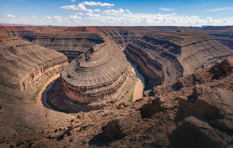
Goosenecks State Park
One overlook, 1,000 feet above the San Juan's goosenecks, with a single motion-sensor light in the whole park.
San Juan River · Cedar Mesa · Bears Ears country
State Park 99 acres 5,200 ft high point Est. 1962 Utah Division of State Parks Dark Sky Park
Overview
Goosenecks is barely a park: a hundred acres of rim, a handful of primitive campsites, a pit toilet, and a view straight down a thousand feet onto the San Juan River doubling back on itself three times in a mile and a half. The meanders are entrenched — the river was already looping when the land rose under it, so it cut down in place and kept its curves. There is no water, no power, no shade and no services. There is exactly one artificial light in the entire park: a motion-activated safety fixture at the entrance station. That, and the emptiness of San Juan County around it, is why the park rates its own sky a Bortle 1 — the darkest class on the scale, though the way it was arrived at matters and we record that too.
Getting in
When to go
Best: Apr, May, Oct
Spring and autumn. Summer is savage — there is no shade at all. Winter nights are long, clear and very cold on an exposed rim.
Safety & conditions
Activities
Stargazing
Certified 2021. The park rates its own sky Bortle 1 and its SQM-L readings averaged 21.82 in 2020 (handheld, zenith) — a figure that cannot be ranked against other parks' meters. One motion-sensor light in the entire park.
Season: Year-round; new-moon windows best. It is exposed and there is no shelter.
The Bortle 1 is a map estimate, not an instrument reading. The 21.82 is real.
Camping
A handful of primitive sites on the rim. No water, no power, no shade.
Regs: First-come. Bring everything.
Hiking
There is no trail. There is a rim, and you stand on it.
Season: Year-round; brutal in summer.
Night Sky
Dark Sky Park Certified 2021 Bortle 1 21.82 mag/arcsec² across 4 sites
There is essentially nothing to move the number except the sky itself: moon, haze, and smoke. The park has ONE artificial light — a motion-activated safety fixture at the entrance station — and San Juan County around it is close to empty. What you get here is what the sky is doing.
What the sky does here
Geology
An entrenched meander: the San Juan was already looping across a flat plain when the Colorado Plateau began to rise. It cut downward faster than it could straighten, so it kept its curves and carved them a thousand feet into the rock. Three hundred million years of Pennsylvanian rock in the walls.
Province: Colorado Plateau — Monument Upwarp
Rock types: limestone, sandstone, shale
Major formations
- Honaker Trail Formation
- Paradox Formation
Ecology
Biomes: Colorado Plateau desert shrubland
Flora
- blackbrush
- Mormon tea
Fauna
- kit fox
- kangaroo rat
- bats
- coyote
- burrowing owl
- scorpions
The application makes a point of it: this is a nocturnal haven, and the animals depend on the darkness. There is one motion-sensor light in the whole park.
History
Goosenecks sits within the ancestral homeland of the Navajo, Ute and Ancestral Puebloan peoples, whose relationship to the San Juan country continues today. It became a Utah state park in 1962.
Modern issues
-
Almost nothing to protect it from
Status: stable
One motion-sensor light in the park and an almost empty county around it. The threat here is regional, not local.