Desert Maritime
Places
The destinations, towns, and specific pieces of ground we keep returning to.
Campgrounds
Big Bend Campground
- Moab / UT-128 Colorado Riverway
- UT
The largest BLM campground on UT-128 — 33 sites total (Sites A, B, C plus 3 reservable group sites), 7.4 mi east of US-191. Sandy beaches, cottonwood shade, direct river access. Sites A and B sit against the river; Site C is in a side canyon across UT-128.
Devils Garden Campground
- Arches National Park
- UT
Arches’ main campground—excellent trail access, but reservations are often required in peak season.
Dewey Bridge Campground
- Moab / UT-128 Colorado Riverway
- UT
7 individual sites + 3 group sites at mile post 29 on UT-128, at the historic Dewey Bridge site. Take-out for Cisco-to-Dewey-Bridge trips and put-in for Dewey-to-Hittle reach. Site of the 1916 suspension bridge that burned in 2008.
Drinks Canyon Camping Area
- Moab / UT-128 Colorado Riverway
- UT
17 sites (4 walk-in) at the mouth of Drinks Canyon, ~6.2 mi east of US-191 on UT-128. Primitive BLM camping with shaded riverside sites.
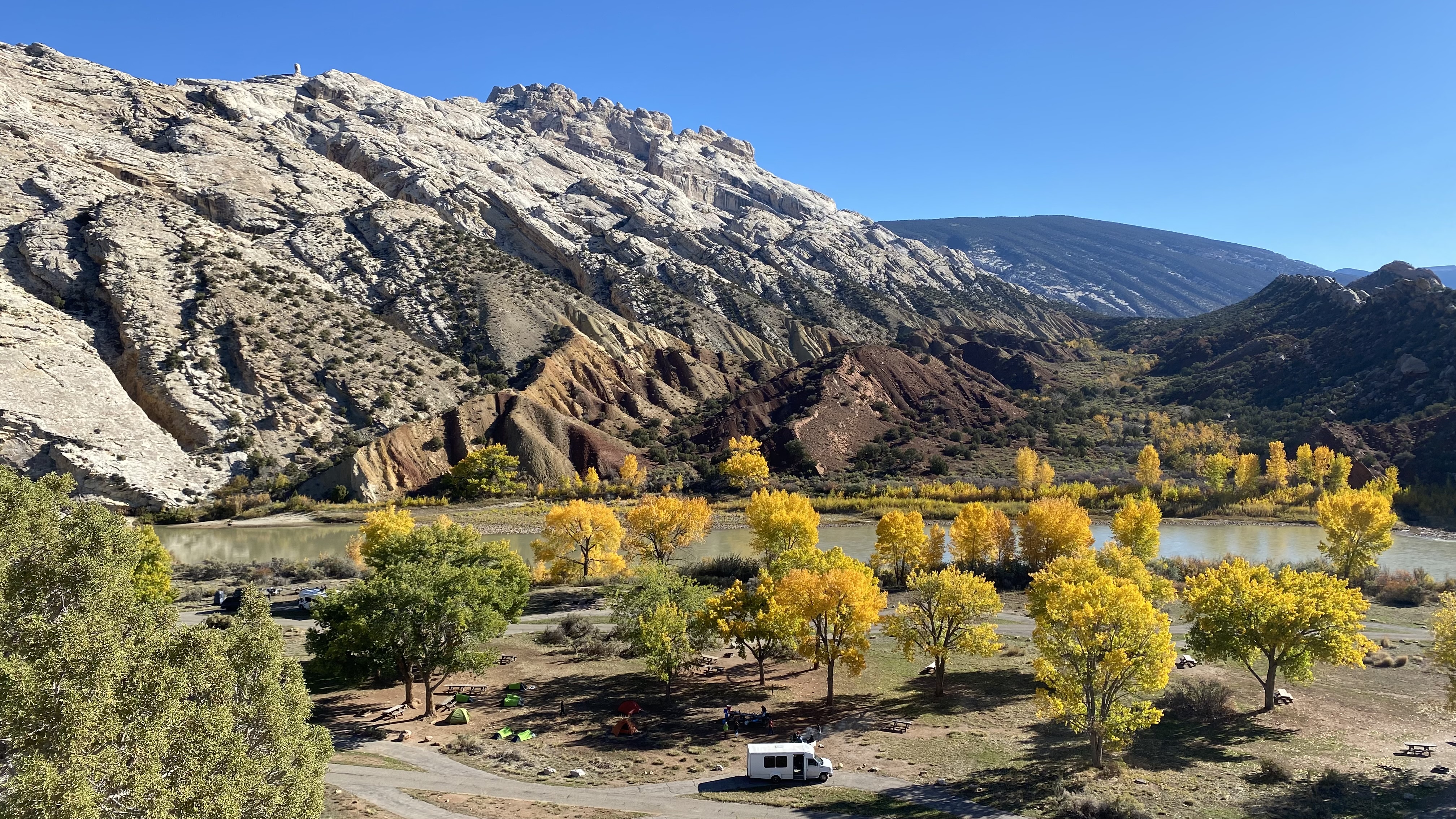
Echo Park Campground
- Dinosaur National Monument
- CO
Vehicle-access NPS campground at the Yampa–Green confluence beneath Steamboat Rock — reached by Echo Park Road from the Harpers Corner highway. Primitive: vault toilets, picnic tables, fire grates, no water, no hookups. A seasonal ranger station and a primitive boat ramp (used in emergencies and for ranger patrols, not as a public put-in or take-out) sit at the confluence. The campground is the closest you can drive to the meeting of two of the West's wildest rivers.
Fisher Towers Campground
- Moab / UT-128 Colorado Riverway
- UT
5 sites beneath the Fisher Towers — iconic Moenkopi/Cutler sandstone spires including Ancient Art (5.11a) and The Titan (900 ft). Accessed via Fisher Towers Road (2 mi off UT-128). NOT riverside; popular with climbers and photographers.
Goose Island Campground
- Moab / UT-128 Colorado Riverway
- UT
Closest BLM river campground to Moab — directly on UT-128 at river mile 65.7 opposite Goose Island. 16 individual + 2 group sites. Heavy use; fills quickly in peak season.
Grandstaff Campground
- Moab / UT-128 Colorado Riverway
- UT
16 tent-only sites (no RVs or trailers) between UT-128 and the Colorado at the mouth of Grandstaff Canyon (formerly Negro Bill Canyon). Adjacent to Grandstaff Canyon Trailhead and Porcupine Rim trailhead.
Hal Canyon Campground
- Moab / UT-128 Colorado Riverway
- UT
11 sites (4 walk-in tent) at the mouth of Hal Canyon side drainage, ~6.6 mi east of US-191. Adjacent to Oak Grove Campground; riverside with cottonwood shade.
Hittle Bottom Campground
- Moab / UT-128 Colorado Riverway
- UT
12 primitive sites at Hittle Bottom Recreation Site (mile post 23), the put-in for Moab Daily trips. Historic Hittle homestead site in Professor Valley. Direct river access; boat ramp on-site.
Indian Crossing Campground
- Browns Park
- UT
USFS campground at the B Section take-out / C Section put-in on the Green River in Browns Park, Utah. Reached by Red Creek Road (~2 miles of gravel) off the upper Browns Park corridor. Co-located with the Indian Crossing boat ramp, making it the natural overnight for trips ending the B Section float or staging the C Section. Quiet, low traffic, and a long way from the busier camps of upper Flaming Gorge.
Lodore Campground
- Dinosaur National Monument
- CO
NPS campground at the Gates of Lodore — the put-in for Lodore Canyon on the Green River. Co-located with the boat ramp, ranger station, and permit check-in. Reached via CO-318 from Maybell, CO (~65 miles of paved highway). The Gates of Lodore Nature Trail leaves directly from the campground and climbs to the overlook where Powell named the canyon in 1869.
Lower Onion Creek Campground
- Moab / UT-128 Colorado Riverway
- UT
21 individual sites + 2 group sites at mile post 22 on UT-128 (accessed via 1.5-mi gravel road opposite the Fisher Towers sign). Two boat ramps on-site. $20/night. 10 people / 2 vehicles per site. 14-night stay limit.
Oak Grove Campground
- Moab / UT-128 Colorado Riverway
- UT
7 sites directly next to Hal Canyon Campground, ~mile post 7 on UT-128. Scrub-oak shade, riverside. $20/night.
Rainbow Park Campground
- Dinosaur National Monument
- UT
Primitive NPS campground on the Green River in the Utah half of Dinosaur National Monument, at the put-in for the Split Mountain day section below Island Park. Reached via a long dirt road (Island Park Road) from Jensen, UT.
Split Mountain Campground
- Dinosaur National Monument
- UT
Developed NPS campground at the take-out boat ramp for Green River multi-day trips through Gates of Lodore and the Yampa. Paved access from Jensen, UT; the staging ground for Dinosaur river trips leaving the water.
Upper Big Bend Campground
- Moab / UT-128 Colorado Riverway
- UT
6-8 individual sites on a bench above the Colorado ~mile post 9 on UT-128. Quieter alternative to nearby Big Bend.
Upper Onion Creek Campground
- Moab / UT-128 Colorado Riverway
- UT
14 individual sites and 2 group sites at mile post 21 on UT-128, at the mouth of Onion Creek. Access to Onion Creek Road and Fisher Mesa country.
National Parks
Arches National Park
- Colorado Plateau
76,000 acres of red sandstone arches, fins, and balanced rock formations north of Moab — the densest concentration of natural arches on Earth.
Canyonlands National Park
- Colorado Plateau
Utah's largest national park — carved by the Colorado and Green Rivers into four districts: Island in the Sky, The Needles, The Maze, and the rivers themselves.
Dead Horse Point State Park
- Colorado Plateau
A 5,360-acre plateau 2,000 feet above a gooseneck bend in the Colorado River — some of the most-photographed canyon country in Utah. Adjacent to Canyonlands National Park.
Dinosaur National Monument
- Uintah Basin / Yampa Plateau
Straddling the Utah-Colorado border along the Green and Yampa rivers — famous paleontology, defining whitewater on the Gates of Lodore and Yampa.
Grand Staircase-Escalante National Monument
- Colorado Plateau
Nearly 1.9 million acres of slickrock, slot canyons, and the Escalante River drainage — a defining piece of Utah canyon country.
Great Basin National Park
- Great Basin
77,000 acres of the Snake Range rising out of eastern Nevada's sagebrush ocean — Wheeler Peak at 13,063 feet, bristlecone pines older than the pyramids, the marble chambers of Lehman Caves, and some of the darkest night skies in the lower 48.
Canyons
Bells Canyon
- Wasatch Range
Steep glacial canyon on the west slope of the central Wasatch, heading at Lone Peak (11,260 ft). Entirely within the Lone Peak Wilderness (designated 1978, 30,088 acres). Quartz monzonite bedrock shared with LCC. Access via three valley-floor trailheads (Boulders, Granite, Preservation). Primary uses: day hiking to the Lower and Upper Falls, strenuous hike to Upper Reservoir and Lone Peak summit, and alpine granite climbing in the Lone Peak Cirque — Triple Overhangs, Vertical Smile, Question Mark Wall. Watershed rules differ from LCC: Bells drains to a private irrigation reservoir, not Salt Lake City's municipal system.
Big Cottonwood Canyon
- Wasatch Range
A mixed V-to-U canyon on the west slope of the central Wasatch, ~12 miles southeast of Salt Lake City along SR-190. Bedrock spans the ~1-billion-year-old Big Cottonwood Formation quartzite (oldest rocks in Utah; tidal rhythmites) and the Cryogenian Mineral Fork Tillite. Skiing (Brighton since 1936, Solitude since 1957), the Lake Blanche / Donut Falls / Brighton Lakes hikes, the Wasatch Crest mountain-bike shuttle, the SR-190 road climb to Guardsman Pass, quartzite climbing at Storm Mountain and the S-Curves, and Salt Lake City's protected drinking-water watershed — strict no-swim, no-dog rules.
Corner Canyon
- Wasatch Range
Corner Canyon is a foothill trail network on the east bench of Draper, where the Wasatch Range meets the Traverse Mountains, roughly 20 miles south of downtown Salt Lake City. It is one of the country's premier municipal mountain-bike systems — 30-plus miles of purpose-built singletrack from about 5,000 to 7,400 feet, including Ghost Falls, Canyon Hollow, Clark's, Rattler, Rush, and the technical Jacob's Ladder — and a heavily used hiking, trail-running, and equestrian area. The terrain is the East Traverse Mountains mega-landslide and the Lake Bonneville shoreline bench; the land was preserved as a regional park in the mid-2000s after Draper voters and the Trust for Public Land headed off a 1,200-home development. Dogs are allowed on-leash below the Bonneville Shoreline Trail but banned in the watershed area above it, and Draper closes trails when they are wet.
Little Cottonwood Canyon
- Wasatch Range
U-shaped glacial gorge on the west slope of the Wasatch, 15 miles southeast of Salt Lake City. Quartz monzonite bedrock, 500+ inches of annual snow at Alta, and the cradle of US avalanche forecasting. Skiing (Alta, Snowbird), trad granite climbing (Gate Buttress, Fin Wall), alpine hiking (Red Pine, Pfeifferhorn, Cecret Lake), a 10.5-mile road-cycling climb, and Salt Lake City's protected drinking-water watershed — strict no-swim/no-dog rules.
Mountain Ranges
La Sal Mountains
- Southeast Utah
A dramatic laccolith range rising above the canyon country near Moab, offering alpine relief from the desert heat.
Wasatch Range
- Northern Utah
A 160-mile north-south range running from southern Idaho to Mount Nebo, forming the eastern wall of the Salt Lake, Utah, and Cache Valleys. The Wasatch divides the Great Basin from the Colorado Plateau province and hosts the densest cluster of glaciated canyons, ski resorts, and front-range wilderness in the western United States.
Wind River Range
- Wyoming
The Winds are a popular recreation destination and the vast wilderness areas attract hikers, climbers and skiers. The Winds have many back country areas that see heavy use despite the relative remoteness of many of the trail-heads and the long approaches from those trail-heads to reach routes. Two of the more popular backpacking destinations are the Titcomb Basin (commonly accessed via the Elkhart Park Trailhead)[7] and the Cirque of the Towers (commonly accessed via the Big Sandy Trailhead).[8] The exposed granite in the higher elevations of the range is particularly attractive to climbers and areas such as Cirque of the Towers in the southern portion of the range are facing overuse issues as a result.[1] According to the White Pine Ski Resort website, the Winds are home to one ski area, White Pine, the only lift-accessible skiing and snowboarding in the range. Located near Pinedale, it is the oldest ski area in Wyoming.
Peaks
American Fork Twin Peaks
- Wasatch Range
- 11,489 ft
The highest summit in the LCC / American Fork divide. Accessed from Snowbird's Mineral Basin (via tram + Peruvian Tunnel), from Hidden Peak, or via longer ridge approaches from American Fork Canyon. Bridge between Mineral Basin skiing and AF Canyon wilderness terrain.
Broads Fork Twin Peaks
- Wasatch Range
- 11,330 ft (E) / 11,328 ft (W)
Paired 11,300-ft summits forming the head of Gad Valley in Little Cottonwood Canyon and the south side of Broads Fork in Big Cottonwood Canyon. Sits within the Twin Peaks Wilderness. Standard approach is from Broads Fork Trailhead in BCC — a Class 3 alpine hike/scramble. From LCC's Gad Valley side (Snowbird's upper terrain), the approach is much steeper and off-trail.
Dromedary Peak
- Wasatch Range
- 11,107 ft
Classic off-trail alpine summit on the Cottonwood Ridge, between Broads Fork Twin Peaks and Sunrise/O'Sullivan. No maintained trail — the standard approach is from Lake Blanche (Big Cottonwood) up to the west ridge; a more direct Class 3+ scramble tops the summit. Part of the Twin Peaks Wilderness.
Gobblers Knob
- Wasatch Range
- 10,246 ft
North-rim Wasatch summit on the divide between Big Cottonwood and Mill Creek canyons. The standard line is Butler Fork in Big Cottonwood to Baker Pass, then up the south ridge — roughly 8 miles round trip and about 3,100 feet of gain, with a short off-trail finish; the peak is also reached from Mill Creek via Bowman Fork and Alexander Basin. The name comes from a failed summit turkey ranch whose birds were picked off by bobcats; it was made official by the U.S. Board on Geographic Names in 1964.
Lone Peak
- Wasatch Range
- 11,260 ft
Signature summit of the Lone Peak Wilderness and head of Bells Canyon. Its northeast cirque — the Lone Peak Cirque — holds some of the best alpine granite climbing in the Lower 48: 400–500 ft walls of clean quartz monzonite, grades from Class 3 to 5.12. The Triple Overhangs (5.10a), Vertical Smile (5.10a), and The Undone Book (5.9+ R) are the cirque's triple crown. The standard hike to the summit from Bells Canyon is one of the hardest day hikes in the Wasatch — ~14 miles and ~5,900 ft of gain.
Mount Baldy (Alta)
- Wasatch Range
- 11,068 ft
Summit at the head of Alta's Albion Basin, home to the Baldy Chutes — five named 40°+ black-diamond gullies (Main Chute into Dog Leg, First Perla's, Tree Chute) that are some of the most technical inbounds ski terrain in the US. Rope-drop terrain, frequently closed for avalanche control. Summer hiking accessible via the Sugarloaf ridgeline from the Alta summer road.
Mount Peale
- La Sal Mountains
- 12,721 ft
The highest summit in the La Sal Mountains and in San Juan County, Utah. A prominent landmark visible from the canyon country around Moab.
Mount Raymond
- Wasatch Range
- 10,241 ft
North-rim Wasatch summit on the divide between Big Cottonwood and Mill Creek canyons, about 1.5 miles west of Gobblers Knob along the same ridge. The standard line climbs from Butler Fork in Big Cottonwood to Baker Pass, then follows the ridge to the peak; most parties tag both summits in one outing. The final summit block is a short Class 2-3 scramble.
Mount Superior
- Wasatch Range
- 11,045 ft
Steep, chiseled summit on the north wall of Little Cottonwood Canyon between Alta and Cardiff Fork. Famous for its south face — a 4,500-ft S4-rated ski descent that appears in Fifty Classic Ski Descents of North America. The summer scramble from the Cardiff Pass side is a non-trivial Class 3 ridgeline.
Pfeifferhorn
- Wasatch Range
- 11,326 ft
A sharp granite summit on the south divide of Little Cottonwood Canyon, nicknamed the 'Little Matterhorn' for its abrupt triangular profile when viewed from the Salt Lake Valley. The standard approach climbs from the White Pine / Red Pine Trailhead past Red Pine Lake, gaining the west ridge via a Class 3 boulder traverse with an exposed knife-edge section just below the summit. One of the signature Wasatch summit-hikes.
Ski Resorts
Alta Ski Area
- Wasatch Range
Alta is the cathedral. Sitting at the head of Little Cottonwood Canyon one mile above Snowbird, it receives the same 500+ inches of annual snowfall but holds it differently — the terrain is more open, the circulation more alpine, the experience more raw. Alta is one of three remaining skier-only resorts in North America, and the decision to ban snowboarding is both its most controversial feature and its clearest statement of identity: this mountain is for skiing, and skiing only. The terrain rewards all abilities but belongs to experts. Alf's High Rustler, the Baldy Chutes, and the vast open powder fields of Greeley Hill and Wildcat are among the most revered runs in American skiing. Alta's lift infrastructure is deliberately modest — no high-speed six-packs, no heated seats — and the base area retains the scruffy, functional character of a mining town that never fully committed to being a resort. The skiing is the thing.
Brighton
- Wasatch Range
Brighton sits at the top of Big Cottonwood Canyon, surrounded on three sides by ridgeline terrain that connects to Solitude, Park City, and the backcountry beyond. It is Utah's oldest ski resort — operating since 1936 — and remains the Wasatch's most accessible and unpretentious mountain. The terrain is varied enough to develop real skiers: mellow groomers at the base, legitimate steeps off Millicent and Milly, and tree skiing that rewards exploration. Brighton was the first Utah resort to allow snowboarding, and the park and pipe culture runs deep. Night skiing under lights is a Salt Lake institution — the closest thing the city has to a neighborhood ski hill. The backcountry access is world-class: Catherine Pass, Days Fork, Silver Fork, and the entire Big Cottonwood ridgeline are minutes from the top of the Great Western chair.
Deer Valley Resort
- Wasatch Range
Deer Valley is the most manicured ski resort in North America. Every run is groomed to velvet. Every lodge serves real food on real plates. The daily skier count is capped. And like Alta, snowboarding is prohibited — Deer Valley and Alta are the only two resorts in Utah that maintain a skiers-only policy. The mountain spans six peaks and over 2,000 acres, with an expansion to Jordanelle opening new terrain. The skiing is excellent: perfectly pitched intermediate groomers that reward clean carving, and genuine expert terrain on Empire Canyon, Daly Chutes, and Lady Morgan Bowl that most visitors never find. Deer Valley's identity is luxury — it hosted the freestyle and slalom events in the 2002 Olympics not because it was the gnarliest mountain but because it was the most polished. The resort proves that service, attention to detail, and world-class grooming are legitimate skiing values.
Nordic Valley
- Wasatch Range
Small Ogden Valley resort — 140 acres, approachable terrain, night skiing. The local hill for the eastern Wasatch Front.
Park City Mountain
- Wasatch Range
Park City Mountain is the largest ski resort in the United States. After Vail Resorts merged the former Park City Mountain Resort and Canyons Resort in 2015, the combined operation spans over 7,300 acres across two interconnected base areas — Park City Base and Canyons Village — connected by the Quicksilver Gondola. The terrain is vast and varied: gentle groomers in the Park City base area, legitimate steeps in Jupiter Bowl and McConkey's, and endless intermediate cruising across the Canyons side. The resort hosted multiple events during the 2002 Winter Olympics and remains the home of the U.S. Ski and Snowboard team. Park City the town is a former silver mining settlement turned destination resort community, with Historic Main Street, the Sundance Film Festival, and a walkable downtown that serves as the social and commercial hub of Utah's ski industry. The skiing is good. The infrastructure is excellent. The scene is unmistakable.
Powder Mountain
- Wasatch Range
Powder Mountain sits above Eden, UT with the largest skiable acreage of any North American resort. The terrain stays uncrowded because daily skier numbers are capped. A skier's mountain without the destination-resort pretense.
Snowbasin Resort
- Wasatch Range
Snowbasin is the Wasatch's best-kept open secret and one of the most underrated ski resorts in North America. Sitting above Ogden Valley on the northern end of the Wasatch Range, it hosted the 2002 Olympic downhill, Super-G, and combined events — and the infrastructure built for those games transformed a quiet local hill into a world-class mountain with Olympic-grade lodges, high-speed lifts, and meticulously maintained terrain. The mountain has 3,000 acres of skiable terrain, 3,000 feet of vertical, and a snow record that rivals the Cottonwood Canyons. What it doesn't have is crowds. Snowbasin's distance from Salt Lake City (45+ minutes via I-15 and Trappers Loop) and its lack of slopeside lodging or base village keep visitation well below capacity. The result is a mountain where you ski powder two days after a storm, ride lifts without waiting, and eat lunch in lodges that would be at home in the Swiss Alps. The terrain is big, open, and sustained — John Paul and Allen Peak deliver 3,000 continuous vertical feet of fall-line skiing. Earl's Traverse, Strawberry Express, and the DeMoisy trees offer intermediate and expert variety. Snowbasin is owned by Sinclair Oil's Earl Holding family and operates with the quiet confidence of a resort that doesn't need to market itself.
Snowbird
- Wasatch Range
Snowbird sits at the head of Little Cottonwood Canyon, 29 miles from downtown Salt Lake City. It is one of the steepest, deepest, and most consistently snow-covered resorts in North America. The resort averages over 500 inches of snow annually — the lightest-density powder in the Wasatch, fed by Great Salt Lake effect storms crossing the Oquirrh Mountains. The terrain is big, exposed, and alpine in character: chutes, cirques, and sustained steeps that reward strong skiing and punish hesitation. The Aerial Tram — one of only two in North America — delivers skiers 2,900 vertical feet to the summit of Hidden Peak in under ten minutes. In summer, the mountain runs hiking, via ferrata, alpine slides, and mountain coaster operations. Snowbird has been a proving ground for expert skiers since 1971 and remains the Wasatch's most serious mountain.
Solitude Mountain Resort
- Wasatch Range
Solitude sits mid-canyon in Big Cottonwood, two miles below Brighton and a world apart in character. The mountain is quieter, the terrain more varied, and the snow — protected by steep canyon walls — holds quality longer than its neighbors. The resort's 1,200 acres spread across three bowls and a long ridgeline, with a mix of perfectly groomed cruisers, steep chutes off Headwall, and genuine glade skiing through Honeycomb Canyon. Solitude joined the Ikon Pass in 2018 after decades as an independent, which brought crowds but hasn't erased the mountain's fundamental personality: unhurried, beautiful, and just serious enough. The Nordic Center at Silver Lake offers some of the best cross-country skiing in the Wasatch. Honeycomb Canyon — a vast, north-facing powder stash accessed by a single traverse — is one of the great hidden zones in Utah skiing.
Woodward Park City
- Wasatch Range
Woodward Park City is not a traditional ski resort. It's an action sports campus built around progression — a place where skiing, snowboarding, skateboarding, BMX, scootering, and mountain biking share the same facility and the same ethos. The ski terrain is small (124 acres) and the vertical modest (650 ft), but the park features are world-class: massive jump lines, a superpipe, jibs, and an indoor Barn facility with foam pits, trampolines, skate bowls, and a digital freestyle training system. Woodward exists to build skills, not to rack up vertical. It opened in 2019 on the site of the former Gorgoza tubing park near Kimball Junction and has quickly become the training ground for the next generation of freestyle athletes. For families with kids who want to learn park riding, or for adults looking to progress in a controlled environment, there is nothing else like it in the Wasatch.
Restaurants
Moab Brewery
- Southeast Utah
Post-trip burgers and local beer in downtown Moab.
Ray's Tavern
- Southeast Utah
A legendary river-runner institution in Green River, known for cold beer and no-frills burgers.
Tamarisk Restaurant
- Southeast Utah
Riverside diner-meets-family-restaurant on the banks of the Green River in Green River, Utah — a panoramic view of the river through the dining-room windows means you can watch boats float by while you eat. Standard American breakfast/lunch/dinner menu (the trout and the burgers are the headline orders), beer and wine, open seven days a week from early morning to late evening. The Tamarisk has been the boater-and-traveler institution of Green River for decades and sits within a hundred yards of both the Green River State Park take-out and the John Wesley Powell River History Museum.