Canyonlands National Park
A quarter-million acres of canyon cut by two rivers into four separate worlds — the mesa-top overlooks of Island in the Sky, the pinnacles of The Needles, the roadless Maze, and the whitewater of Cataract Canyon.
Canyon Country · Moab · Green–Colorado Confluence
National Park 337,598 acres Est. 1964 National Park Service Dark Sky Park · Gold Tier
Overview
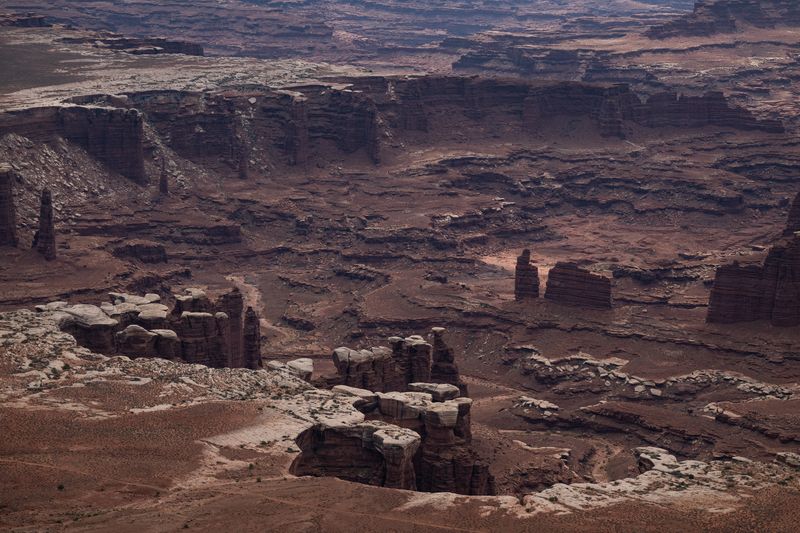
Canyonlands is less a place than a cross-section. The Green and Colorado rivers meet at its center — the Confluence — and the country they've carved falls away from that junction in three great benched levels, split into districts that barely speak to each other. Island in the Sky is the mesa top, a peninsula of overlooks a thousand feet above everything, reached by a paved road and famous for Mesa Arch at dawn and the White Rim spread out below. The Needles, across the Colorado to the southeast, is a walk-in world of banded sandstone pinnacles, Chesler Park, and the Joint Trail. The Maze is the roadless quarter — days from pavement, a place you enter only self-sufficient and sure. And the fourth district is the rivers themselves: flatwater down through Stillwater to the Confluence, then the sudden, committing whitewater of Cataract Canyon below. One park, four commitments — the districts are close as the crow flies and hours apart by road, so you plan Canyonlands one district at a time.
Getting in
When to go
Best: Apr, May, Sep, Oct Shoulder: Mar, Nov Hardest: Jul, Aug
Island in the Sky is busy spring and fall; The Needles is quieter; The Maze is empty by design. Cataract Canyon whitewater peaks with snowmelt in May–June.
July–August exceed 100°F with almost no shade. Spring and fall are ideal; winter is cold, quiet, and often clear.
Safety & conditions
Activities
Hiking
Everything from short mesa-rim walks (Mesa Arch, Grand View Point on Island in the Sky) to serious backcountry loops in The Needles (Chesler Park, Druid Arch, the Joint Trail).
Areas: Island in the Sky rim; The Needles; The Maze
Season: Spring and fall; summer is brutally hot and shadeless.
Little water and less shade — carry your own. The Needles and Maze backcountry demand navigation skills.
Rafting / River
The park's river district runs from flatwater above the Confluence into Cataract Canyon, one of the classic big-water runs of the Colorado Plateau. Permitted, multi-day, and serious at high flows.
Season: Snowmelt (May–June) for peak whitewater; flatwater is a longer season.
Permit required
Regs: River trips require a permit through Recreation.gov (or use a licensed outfitter).
Scenic Driving
Paved scenic drives serve Island in the Sky (to Grand View Point) and The Needles; the White Rim Road and Elephant Hill are legendary backcountry 4WD routes below the rim.
Season: Paved roads year-round; backcountry roads condition-dependent.
White Rim and Elephant Hill require day-use permits and real 4WD capability.
Backpacking
Overnight backcountry in The Needles and The Maze, plus at-large zones — remote, dry, and permit-controlled. The Maze is expedition-grade.
Season: Spring and fall.
Permit required
Overnight permits via Recreation.gov; water sources are scarce and unreliable.
Cycling
The ~100-mile White Rim Road below Island in the Sky is a bucket-list multi-day mountain-bike route, usually ridden with vehicle support.
Season: Spring and fall.
Permit required
Day-use and overnight permits required; no water on the White Rim — plan support.
Stargazing
Certified an International Dark Sky Park in 2015, at what was then Gold Tier. The Park Service read thirteen sites across Island in the Sky and the Needles and averaged 21.85 mag/arcsec² — and the two districts came out statistically identical. Island in the Sky is the accessible dark sky, not the darkest one: it sits closest to Moab, and it holds the brightest site in the whole survey. Every site they measured was within sight of a road. The Maze, the river corridor, and the Needles backcountry are almost certainly darker. Nobody has measured them.
Season: Year-round; new-moon windows best.
Districts
-
Island in the Sky
A paved mesa-top district of overlooks a thousand feet above the White Rim — Mesa Arch, Grand View Point, and the Shafer switchbacks. The most accessible district and the busiest.
Access: ~40 minutes from Moab on paved road (US-191 to UT-313).
-
The Needles
A walk-in district of banded Cedar Mesa Sandstone pinnacles southeast of the Colorado — Chesler Park, Druid Arch, the Joint Trail, and the Elephant Hill 4WD road.
Access: ~1.5 hours south of Moab via US-191 and UT-211.
-
The Maze
The park's roadless quarter — about 1.5% of visitors — reached only by long, rough 4WD roads and demanding full self-sufficiency. One of the most remote areas in the Lower 48.
Access: Remote dirt approach via Hanksville / Hans Flat Ranger Station; multi-hour high-clearance 4WD.
-
The Rivers
The Green and Colorado themselves — flatwater down to the Confluence, then the big whitewater of Cataract Canyon below it. A permitted, multi-day river world.
Access: By river only — flatwater from Green River or Moab; Cataract Canyon on a permit.
Night Sky
Dark Sky Park Gold Tier Certified 2015 Bortle 3 of 2–3 21.85 mag/arcsec² across 13 sites mag 7.1 limit
Bortle 2–3 is the Park Service's assessment, not a promise. The number moves with moonlight, summer haze, wildfire smoke, and which district you are standing in. Island in the Sky carries Moab's light dome on its northeast horizon — an NPS observer logged it from Grand View Point in 2011, along with headlights running the Needles Overlook Road past one in the morning and a glow from oil and gas development south of La Sal. And every one of the thirteen surveyed sites is frontcountry: visitor centers, housing, a campground, roadside overlooks. The 3 is what the pullouts measure. If the 2 is anywhere, it is down on the rivers, out in the Maze, and back in the Needles beyond the road — and nobody has put a meter in any of them.
What the sky does here
Across the park
-
Island in the Sky
21.84 mag/arcsec² range 21.68–21.95 6 sites
The park's most accessible dark sky, and its brightest measured one. Closest district to Moab — 24.7 miles, azimuth 42° — and Candlestick Tower Overlook, at 21.68, is the brightest of all thirteen sites surveyed. An NPS observer at Grand View Point logged Moab's dome on the horizon, headlights on the Needles Overlook Road, and oil-and-gas glow south of La Sal.
Light domes: Moab, La Sal Junction, BLM oil and gas development
-
The Needles
21.86 mag/arcsec² range 21.69–22.02 7 sites
Holds the darkest site in the survey: Squaw Flat Campground at 22.02. On paper it is indistinguishable from Island in the Sky — 0.03 mag apart, well inside the noise — despite being the harder district to reach. But all seven sites sit in the frontcountry. The backcountry beyond the road has never been read, and that is where the dark end of the Park Service's 2–3 range most likely lives.
-
The Maze
Never measured
Never measured. The 2015 survey placed zero sites here. It is widely assumed to be the darkest district in the park — assumed, not measured.
-
The Rivers
Never measured
Never measured. No meter was ever placed on the Green or the Colorado inside the park. Worth holding alongside what the nomination package says about where light domes live: 'only dim and restricted to sky close to horizon.' On the river you are below the rim, and the rim takes the horizon away.
Geology
Underlain by the same Paradox salt as Arches and Moab — salt movement warps the strata, and at Upheaval Dome it produced a still-debated deformed crater (salt dome or meteorite impact). The banding of The Needles is the Cedar Mesa Sandstone's alternating red and white beds.
Province: Colorado Plateau — Canyonlands Section (Paradox Basin)
Rock types: sandstone, shale, limestone
Major formations
- White Rim Sandstone
- Cedar Mesa Sandstone
- Cutler Group
- Honaker Trail Formation
Ecology
Biomes: Colorado Plateau high desert / cold desert shrubland; pinyon-juniper woodland; biological soil crust (cryptobiotic) communities; riparian corridor along the Green and Colorado rivers
Flora
- Utah juniper and pinyon pine
- blackbrush
- Fremont cottonwood (river corridors)
- cryptobiotic soil crust
Fauna
- desert bighorn sheep
- mule deer
- mountain lion
- peregrine falcon
- collared lizard
Cryptobiotic soil crust is fragile and everywhere off-trail; 'don't bust the crust' applies across all four districts. The river corridors are green ribbons of cottonwood through otherwise bare rock.
History
Powell's 1869 expedition put the Confluence and Cataract Canyon on the map; the park itself was established in 1964 after a long campaign led in part by Arches superintendent Bates Wilson, the 'father of Canyonlands.'
Indigenous homelands: Ute, Southern Paiute, Pueblo (Ancestral Puebloan) and Fremont — extensive rock art and granaries
Key events
- 1869 John Wesley Powell's expedition descends the Green and Colorado through the future park, naming the Confluence and Cataract Canyon.
- 1964 Canyonlands National Park established (Sept 12), championed by NPS director and Utah interests including Bates Wilson.
- 1971 The Maze / Land of Standing Rocks and other areas added in a boundary expansion.
Notable figures
- John Wesley Powell
- Bates Wilson
Modern issues
-
Backcountry and river permit demand
Status: ongoing
Day-use permits on the White Rim and Elephant Hill (since 2015) and high demand for Cataract Canyon and backcountry permits reflect growing pressure on a park built around solitude. Reserve well ahead.
Access & regulations
Roads
- Island in the Sky entrance road (UT-313 spur) — paved. Year-round. Paved to Grand View Point.
- White Rim Road — rough dirt. Condition-dependent; impassable when wet. ~100-mile backcountry loop; day-use or overnight permit required.
- Maze / Hans Flat roads — rough dirt. Condition-dependent; remote. Expedition-grade 4WD; carry recovery gear and extra supplies.
Accessibility: Several Island in the Sky overlooks have short paved or accessible paths; visitor centers are accessible.