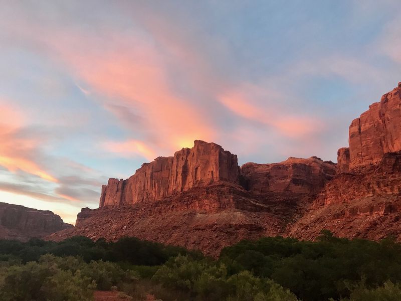
Labyrinth Canyon
Sixty-eight miles of the Green with no rapids and no hurry — Green River State Park to Mineral Bottom, or either half on its own.
Labyrinth Canyon is the Colorado Plateau's flatwater expedition: the Green River from Green River State Park to Mineral Bottom through entrenched meanders under six-hundred-foot Wingate walls, past Trin-Alcove, with no rapids anywhere in it. Sixty-eight miles in four to six days by canoe. Ruby Ranch splits it: twenty-three miles above for a weekend, forty-five below for the deep canyon. A BLM overnight permit is required and self-issued; day floats need none. Spring is the season, wind can be a factor, launching early usually the solve. Mineral Bottom's switchbacks add to the adventure.
Choose your route
-
Green River State Park to Mineral Bottom classic
Green River State Park → Mineral Bottom
- Miles
- 68
- Days
- 4–7
- Sections
- 1
The whole of Labyrinth Canyon, Green River State Park to Mineral Bottom.
Permit Labyrinth Canyon permit · self-issued
Spring is the sweet spot — moderate temperatures, good flows, and desert wildflowers. Summer is hot but manageable with shade camping and early starts.
-
Green River State Park to Ruby Ranch
Green River State Park → Ruby Ranch Boat Ramp
- Miles
- 23
- Days
- 1–3
- Sections
- 1
Upper Labyrinth only, taking out at Ruby Ranch.
Permit Labyrinth Canyon permit · self-issued
Spring is ideal — temperatures moderate and canyon colors most vivid. Summer is possible but hot; carry extra water capacity.
-
Ruby Ranch to Mineral Bottom
Ruby Ranch Boat Ramp → Mineral Bottom
- Miles
- 45
- Days
- 3–5
- Sections
- 1
Enters at Ruby Ranch for the middle and lower canyon — the shorter float.
Permit Labyrinth Canyon permit · self-issued
Spring offers the best paddling conditions. Summer heat is manageable with early starts and shade camping.
Green River State Park to Mineral Bottom
Full Labyrinth Canyon traverse from Green River city to Mineral Bottom. Approximately 68 miles of desert flatwater through progressively deepening canyon walls. The defining multi-day flatwater trip on the Colorado Plateau — a canoe and packraft classic with no whitewater and total canyon immersion.
- Distance
- 68 miles
- Typical days
- 5
The journey
What the water is doing
Bands keyed to Green River at Green River, UT
-
1,000–2,000 cfs
Low — minimum comfortable
current
Minimum comfortable flow. Slow current; paddlers must work harder, especially against afternoon headwinds.
-
2,000–6,000 cfs
Optimal range
current
Best conditions for most groups. Good current assists downstream progress through meanders.
-
6,000+ cfs
High water
current
Strong current; camps may be partially flooded and sandy bars reduced. Fast-moving flatwater.
Flow knowledge is owned by the Labyrinth Canyon section record — full flow spectrum and history there.
Access
- Put-in
- Green River State Park
- Take-out
- Mineral Bottom
Green River State Park to Ruby Ranch
Upper Labyrinth Canyon from Green River city to Ruby Ranch. 23 miles of flatwater per BLM Labyrinth Canyon River and NPS-derived mileage (GRSP->Confluence 122; Ruby Ranch->Confluence 99; 122-99=23). No whitewater. A short upper-Labyrinth float, often run as a weekend warm-up or the opening leg of a longer multi-day descent to Mineral Bottom or the Confluence.
- Distance
- 23 miles
- Typical days
- 2
The journey
What the water is doing
Bands keyed to Green River at Green River, UT
-
1,000–2,000 cfs
Low — minimum comfortable
current
Minimum comfortable flow. Slow current; paddlers must work harder, especially against afternoon headwinds.
-
2,000–6,000 cfs
Optimal range
current
Best conditions for most groups. Good current assists downstream progress through meanders.
-
6,000+ cfs
High water
current
Strong current; camps may be partially flooded and sandy bars reduced. Fast-moving flatwater.
Flow knowledge is owned by the Labyrinth Canyon section record — full flow spectrum and history there.
Access
- Put-in
- Green River State Park
- Take-out
- Ruby Ranch Boat Ramp
Ruby Ranch to Mineral Bottom
Middle and lower Labyrinth Canyon from Ruby Ranch to Mineral Bottom. 45 miles of flatwater through the canyon's deepest sandstone walls and through Trin Alcove (Three Canyon) at the landmark Powell-named bend. The core of the Labyrinth Canyon experience for paddlers who skip the upper 23 miles from Green River State Park. Canoe and packraft classic with no whitewater.
- Distance
- 45 miles
- Typical days
- 4
The journey
What the water is doing
Bands keyed to Green River at Green River, UT
-
1,000–2,000 cfs
Low — minimum comfortable
current
Minimum comfortable flow. Slow current; paddlers must work harder, especially against afternoon headwinds.
-
2,000–6,000 cfs
Optimal range
current
Best conditions for most groups. Good current assists downstream progress through meanders.
-
6,000+ cfs
High water
current
Strong current; camps may be partially flooded and sandy bars reduced. Fast-moving flatwater.
Flow knowledge is owned by the Labyrinth Canyon section record — full flow spectrum and history there.
Access
- Put-in
- Ruby Ranch Boat Ramp
- Take-out
- Mineral Bottom