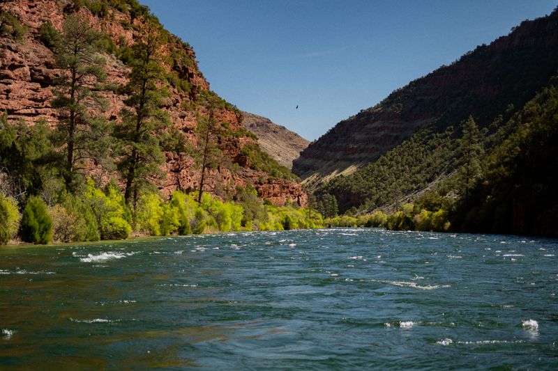
Green River Spillway
Cold, clear tailwater below Flaming Gorge — four stretches, one corridor, pick your water.
The Green below Flaming Gorge Dam is tailwater — cold, clear, and running on the dam's schedule, which is what makes it one of the West's great trout fisheries. Four stretches share the corridor: the A Section's canyon drift from the spillway, the quieter B and C Sections, and the long open miles of Browns Park. Pick a stretch and float it in a day, or link all four to the gates of Lodore.
Choose your route
-
A Section classic
Spillway Boat Launch → Little Hole
- Miles
- 7
- Days
- 1
- Sections
- 1
Spillway to Little Hole: seven miles of Blue-Ribbon fishing, the classic drift.
Permit No permit required
Year-round float possible. Cold water year-round. Best air temperatures May–October.
-
B Section
Little Hole → Indian Crossing
- Miles
- 9
- Sections
- 1
Little Hole to Indian Crossing — nine quieter miles below the crowds.
-
A + B Day Float
Spillway Boat Launch → Indian Crossing
- Miles
- 16
- Days
- 1
- Sections
- 2
A and B back to back — sixteen miles, one epic day on the water.
-
C Section
Indian Crossing → Swallow Canyon Boat Ramp
- Miles
- 10.8
- Sections
- 1
Indian Crossing through Swallow Canyon, land the big ones.
-
Browns Park
Swallow Canyon Boat Ramp → Gates of Lodore Put-in
- Miles
- 18
- Sections
- 1
Eighteen open miles through the valley to the Gates of Lodore.
-
Full Corridor
Spillway Boat Launch → Gates of Lodore Put-in
- Miles
- 44.8
- Sections
- 4
All four stretches, spillway to Lodore — the whole tailwater in one float.
A Section
The Flaming Gorge Dam to Little Hole route is the classic day float through Red Canyon below the dam — 7 miles of cold, clear tailwater through one of the most dramatic canyon corridors on the upper Green River. World-class trout fishing, extraordinary geology, and towering red sandstone walls make this the premier short float in the Flaming Gorge NRA.
- Distance
- 7 miles
- Typical days
- 1
The journey
What the water is doing
Bands keyed to Green River near Greendale, UT
-
800–3,000 cfs
Ideal
current
Comfortable float with good riffles and manageable current.
-
3,000+ cfs
High
current
Fast and cold. Dress for immersion. Experienced paddlers.
Flow knowledge is owned by the A Section section record — full flow spectrum and history there.
Access
- Put-in
- Spillway Boat Launch
- Take-out
- Little Hole
B Section
The B Section on its own: Little Hole down to the Indian Crossing ramp, where the Green leaves Red Canyon and opens into upper Browns Park. Fewer anglers than the A Section above, because the only ways in are by boat or a long gravel road, and bigger fish, the twenty-five-inch browns the section is known for. Steady tailwater current with defined riffles at Washboard and Red Creek, cottonwood camps along the way, and no float permit. Dam-release water runs cold year-round here, so dress for immersion.
- Distance
- 9 miles
The journey
Access
- Put-in
- Little Hole
- Take-out
- Indian Crossing
A + B Day Float
A and B back to back: launch below the dam, drift Red Canyon's quartzite walls to Little Hole, and keep going past the crowds into the open valley at Indian Crossing. Commonly floated in one long day, with the morning in the canyon and the afternoon in Browns Park. No float permit; the NRA entrance fee applies at the top. Dam releases change through the day with power generation, so check the schedule before you launch, and expect cold water start to finish.
- Distance
- 16 miles
- Typical days
- 1
The geography underneath
One recognizable trip, 2 named river sections. The trip has one name; the river carries you through more geography than that name reveals.
The journey
What the water is doing
Bands keyed to Green River near Greendale, UT
-
800–3,000 cfs
Ideal
current
Comfortable float with good riffles and manageable current.
-
3,000+ cfs
High
current
Fast and cold. Dress for immersion. Experienced paddlers.
Flow knowledge is owned by the A Section section record — full flow spectrum and history there.
Access
- Put-in
- Spillway Boat Launch
- Take-out
- Indian Crossing
C Section
Indian Crossing through Swallow Canyon to the ramp at the canyon's east exit: the C Section, cold clear dam-release water in a narrow cottonwood-lined canyon on the Colorado–Utah line, with mellow riffles, osprey on the cliffs, and the big browns of Browns Park. No launch permit. Regulated flow means the run is consistent all season where snowmelt rivers are not; the water is cold regardless. A day trip for most parties, or an overnight at one of the camps along the canyon. Both ramps are reached by dirt through Browns Park.
- Distance
- 10.8 miles
The journey
Access
- Put-in
- Indian Crossing
- Take-out
- Swallow Canyon Boat Ramp
Browns Park
Browns Park on its own: from the Swallow Canyon ramp through the wide valley of cottonwood groves, wetlands, and open range where the Wild Bunch wintered, to the put-in at the foot of the Gates of Lodore. Class I flatwater, rich with wildlife, and the most abrupt transition on the Green: open sky and sage flats, then vertical red walls. No permit to float the park; the Gates of Lodore is an NPS lottery put-in, so this route ends where the permit system begins. Camping is generally allowed on the BLM and refuge lands. The shuttle is dirt through the park, high clearance after weather. Two or three easy days for a family or a canoer.
- Distance
- 18 miles
The journey
Access
- Put-in
- Swallow Canyon Boat Ramp
- Take-out
- Gates of Lodore Put-in
Full Corridor
Launch at the base of the Flaming Gorge Dam through Red Canyon to Little Hole, the B Section's big-fish water to Indian Crossing, Swallow Canyon, and then Browns Park all the way to the Gates of Lodore. Four sections, no float permit on any of them, and cold, dam-regulated water the entire way, so the trip runs in summer when the snowmelt rivers are dropping. Plan it as a multi-day with camps in the B Section, Swallow Canyon, and the park. It ends at the Lodore put-in, where the NPS permit system begins; a party with a Lodore lottery date can treat this as the approach and launch into the canyon with the river already under them.
- Distance
- 44.8 miles
The geography underneath
One recognizable trip, 4 named river sections. The trip has one name; the river carries you through more geography than that name reveals.
- A Section 7 mi the journey
- B Section 9 mi the journey
- Swallow Canyon 10.8 mi the journey
- Browns Park 18 mi the journey
The journey
What the water is doing
Bands keyed to Green River near Greendale, UT
-
800–3,000 cfs
Ideal
current
Comfortable float with good riffles and manageable current.
-
3,000+ cfs
High
current
Fast and cold. Dress for immersion. Experienced paddlers.
Flow knowledge is owned by the A Section section record — full flow spectrum and history there.
Access
- Put-in
- Spillway Boat Launch
- Take-out
- Gates of Lodore Put-in