Westwater Canyon
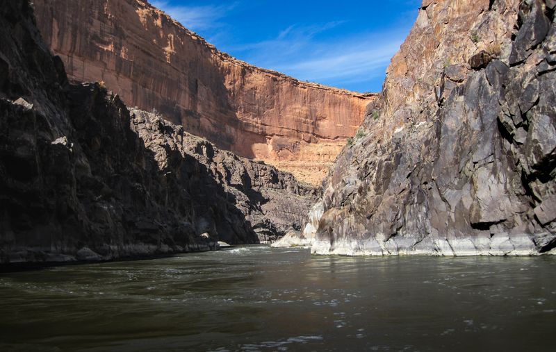
Seventeen miles into black Precambrian rock — Skull, the Room of Doom, and the Colorado's most concentrated Class IV, runnable in a day on a BLM permit.
Westwater is the short permit trip of the Moab region: seventeen miles from the Westwater Ranger Station to the Cisco ramp, six of them through open red sandstone and the rest inside a gorge of 1.7-billion-year-old black granite and schist. The rapids compress as the walls close, Little Dolores, Marble Canyon, Staircase, Big Hummer, Funnel Falls, Surprise, then Skull with the Room of Doom, Sock-It-To-Me, Bowling Alley, and Last Chance. Class III–IV, with the gorge turning expert-only at high water when the Room of Doom becomes a keeper. Most parties run it in one long day; an overnight in the gorge is worth it. A BLM Moab Field Office permit is required year-round for day use and overnight, booked on a rolling two-month window and competitive in season. The shuttle is paved, twenty road miles, one of the easiest on the Plateau. Pair it with Ruby–Horsethief above for the three-to-four-day version.
Choose your route
-
Westwater to Cisco classic
Westwater Ranger Station Boat Ramp → Cisco Boat Ramp
- Miles
- 17
- Days
- 1–2
- Sections
- 1
The standard run: ranger station to Cisco Landing, seventeen miles with the black gorge and Skull in the middle, in a day or with a night in the canyon.
Permit Westwater Canyon River Permits
Spring and fall are ideal. Summer is hot but manageable. Fisher Towers glow red in late-afternoon fall light.
-
Ruby–Horsethief and Westwater
Loma Boat Ramp → Cisco Boat Ramp
- Miles
- 41.6
- Days
- 3–5
- Sections
- 2
Two permits, one float: the Wingate walls and big camps of Ruby–Horsethief, then straight into Westwater's black gorge, Loma to Cisco.
Permits Ruby-Horsethief Overnight Camping Permit · Westwater Canyon River Permits
-
Westwater to Dewey Bridge
Westwater Ranger Station Boat Ramp → Dewey Bridge Boat Ramp
- Miles
- 33.3
- Days
- 2–3
- Sections
- 2
Run the gorge, then keep going: sixteen quiet flatwater miles below Cisco to the Dewey Bridge ramp instead of the usual take-out.
Westwater to Cisco
Westwater Canyon — 17 miles of Colorado River from the Westwater Ranger Station put-in down through Utah's tightest Precambrian-rock gorge to the Cisco Boat Ramp take-out. The 'short permit trip' of the Moab region: Class III-IV+ whitewater concentrated in a dramatic black-rock inner gorge, including Little Dolores, Marble Canyon, Staircase, Big Hummer, Funnel Falls, Surprise, Skull Rapid (with Room of Doom), Sock-It-To-Me, Bowling Alley, and Last Chance. A full-day or overnight run — the canyon's combination of serious rapids, committed walls, and relatively short length make it one of the most requested permits in the West.
- Distance
- 17 miles
- Typical days
- 2
The journey
What the water is doing
Bands keyed to Colorado River Near Cisco, UT
-
1,500–3,000 cfs
Low
current
Runnable but more technical — scraping possible on exposed ledges. Razor rock is out; time the eddy above so the boat spin doesn't need a counter-spin.
-
3,000–12,000 cfs
Sweet spot
current
Best conditions for most groups. Skull is well-formed and readable.
-
12,000–16,000 cfs
High water
current
14,400 cfs is the fabled level where expert boaters say Westwater's frequency peaks. Expert paddlers and properly-rigged boats only.
-
16,000+ cfs
Big water
current
Some features flooded, others max punishment; more room to get around the big stuff. Room of Doom a serious keeper. Expert paddlers and properly-rigged boats only.
Flow knowledge is owned by the Westwater Canyon section record — full flow spectrum and history there.
Access
- Put-in
- Westwater Ranger Station Boat Ramp
- Take-out
- Cisco Boat Ramp
Ruby–Horsethief and Westwater
The combined trip: launch at Loma and float the twenty-five flatwater miles of Ruby–Horsethief past Black Rocks and Mee Canyon, pass the Westwater Ranger Station without taking out, and run the gorge to Cisco. Two BLM permits from two field offices, Grand Junction for the Ruby–Horsethief overnight and Moab for Westwater, on the same dates. Three to five days, most often four. Class I–II water for the first day or two, then Class III–IV, so the crew and the boats have to be rigged for the second half from the start.
- Distance
- 41.6 miles
- Typical days
- 4
The geography underneath
One recognizable trip, 2 named river sections. The trip has one name; the river carries you through more geography than that name reveals.
- Ruby–Horsethief Canyon 25 mi approach
- Westwater Canyon 17.2 mi the journey
The journey
What the water is doing
Bands keyed to Colorado River Near Cisco, UT
-
1,500–3,000 cfs
Low
current
Runnable but more technical — scraping possible on exposed ledges. Razor rock is out; time the eddy above so the boat spin doesn't need a counter-spin.
-
3,000–12,000 cfs
Sweet spot
current
Best conditions for most groups. Skull is well-formed and readable.
-
12,000–16,000 cfs
High water
current
14,400 cfs is the fabled level where expert boaters say Westwater's frequency peaks. Expert paddlers and properly-rigged boats only.
-
16,000+ cfs
Big water
current
Some features flooded, others max punishment; more room to get around the big stuff. Room of Doom a serious keeper. Expert paddlers and properly-rigged boats only.
Flow knowledge is owned by the Westwater Canyon section record — full flow spectrum and history there.
Access
- Put-in
- Loma Boat Ramp
- Take-out
- Cisco Boat Ramp
Westwater to Dewey Bridge
Westwater with the flatwater tail: the ranger station put-in, the black-rock gorge and Skull, then past the Cisco ramp where most parties leave and on through sixteen miles of open BLM ranchland and shale badlands to the Dewey Bridge ramp, with the Book Cliffs north and the La Sals south. The Westwater permit covers the gorge; nothing is required below Cisco, and beach camping on the BLM benches is allowed. Two days is the natural plan, three if Westwater gets its own night. The shuttle is paved the whole way, UT-128 to I-70.
- Distance
- 33.3 miles
- Typical days
- 2
The geography underneath
One recognizable trip, 2 named river sections. The trip has one name; the river carries you through more geography than that name reveals.
- Westwater Canyon 17.2 mi the journey
- Cisco to Dewey Bridge 16.1 mi approach
The journey
What the water is doing
Bands keyed to Colorado River Near Cisco, UT
-
1,500–3,000 cfs
Low
current
Runnable but more technical — scraping possible on exposed ledges. Razor rock is out; time the eddy above so the boat spin doesn't need a counter-spin.
-
3,000–12,000 cfs
Sweet spot
current
Best conditions for most groups. Skull is well-formed and readable.
-
12,000–16,000 cfs
High water
current
14,400 cfs is the fabled level where expert boaters say Westwater's frequency peaks. Expert paddlers and properly-rigged boats only.
-
16,000+ cfs
Big water
current
Some features flooded, others max punishment; more room to get around the big stuff. Room of Doom a serious keeper. Expert paddlers and properly-rigged boats only.
Flow knowledge is owned by the Westwater Canyon section record — full flow spectrum and history there.
Access
- Put-in
- Westwater Ranger Station Boat Ramp
- Take-out
- Dewey Bridge Boat Ramp