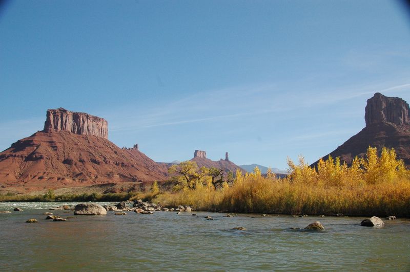
Moab Daily
The classic Hittle Bottom to Take-Out Beach run through Professor Valley — plus every other ramp combination between Dewey Bridge and Potash, so you can pick the stretch that fits the day.
The Moab Daily is the most-run day water on the Colorado Plateau, and it is no longer one trip. The classic run is Hittle Bottom to Take-Out Beach — fourteen miles through Professor Valley past Onion Creek, Professor Creek and the wave train at Rocky Rapid, under the Fisher Towers and the red walls of Castle Valley. That is still the default, and still what most people mean when they say they floated the Daily. But the ramps have multiplied. You can start higher at Dewey Bridge and add the quiet six miles above Hittle, or lower at Fisher Towers for a half-day. You can keep going below Take-Out Beach through the town stretch past Big Bend and Granstaff, or carry on through the Portal — where the river leaves the valley and enters Canyonlands between eight hundred feet of sandstone — all the way to Potash, where Meander Canyon and the long run to the Confluence begin. Forty-seven miles end to end, and every ramp between is a legitimate place to start or stop. This page is the whole corridor. Pick the stretch you actually want.
Choose your route
-
Hittle Bottom to Take-Out Beach classic
Hittle Bottom → Take Out Beach
- Miles
- 13.8
- Sections
- 1
The classic Moab Daily. Hittle Bottom to Take-Out Beach through Professor Valley — Onion Creek, Professor Creek and Rocky Rapid — the run most people mean when they say they floated the Daily.
-
Dewey Bridge to Hittle Bottom
Dewey Bridge Boat Ramp → Hittle Bottom
- Miles
- 6.3
- Sections
- 1
The top of the corridor on its own — six quiet miles from the old Dewey Bridge site down to Hittle Bottom, entering Professor Valley from above. Flatwater and easy riffles with UT-128 alongside the whole way, which makes it the simplest shuttle on the river and a short float in its own right.
-
Fisher Towers to Take-Out Beach
Lower Onion Creek Boat Ramp → Take Out Beach
- Miles
- 11.1
- Sections
- 1
The short version, launching below Hittle at the Fisher Towers ramp. Same water, less of it — the common commercial half-day.
-
Rocky Rapid to Take-Out Beach
Rocky Rapid Boat Ramp → Take Out Beach
- Miles
- 6.4
- Sections
- 1
The short Daily. Launch just below Rocky Rapid, run Whites and Salt Wash, and take out six miles down at Take-Out Beach: the least shuttle in the corridor with moving water still in it.
-
Dewey Bridge to Take-Out Beach
Dewey Bridge Boat Ramp → Take Out Beach
- Miles
- 20.1
- Sections
- 2
Adds the quiet six miles above Hittle, entering Professor Valley from the top at the old Dewey Bridge site.
-
Take-Out Beach to Moab Bridge
Take Out Beach → Moab Bridge Boat Ramp
- Miles
- 9.9
- Sections
- 1
The town stretch below the Daily — Big Bend, Granstaff and Goose Island — where the river runs past the campgrounds on UT-128 into Moab.
-
Rocky Rapid to Moab Bridge
Rocky Rapid Boat Ramp → Moab Bridge Boat Ramp
- Miles
- 16.3
- Sections
- 2
The Rocky Rapid Landing through the bottom of Professor Valley and on down the town stretch past Big Bend, Grandstaff and Goose Island to the Moab Bridge — the lower half of the corridor without the drive up to Hittle.
-
Moab Bridge to Potash
Moab Bridge Boat Ramp → Potash Boat Ramp
- Miles
- 17
- Sections
- 1
Through the Portal, where the Colorado leaves the valley and enters Canyonlands country between 800-foot walls of Chinle up to Navajo Sandstone.
-
Hittle Bottom to Potash
Hittle Bottom → Potash Boat Ramp
- Miles
- 40.7
- Sections
- 3
The Daily and everything below it — Professor Valley, the town stretch, and the Portal — in one multi-day push.
-
Dewey Bridge to Potash
Dewey Bridge Boat Ramp → Potash Boat Ramp
- Miles
- 47
- Sections
- 4
The full corridor: every mile of the Colorado from the old Dewey Bridge site to the Potash ramp, where Meander Canyon and the run to the Confluence begin.
Hittle Bottom to Take-Out Beach
The classic Moab Daily. Fourteen miles from Hittle Bottom to Take-Out Beach through Professor Valley, under the Fisher Towers and the Castle Valley walls, with the named drops arriving in order: Onion Creek, Professor Creek, New Rapid, then Rocky, the one real wave train, followed by Whites and Salt Wash on the way out. Class I–II water that runs in four to six hours at typical flows, faster in spring. The Daily's flow is Cisco plus the Dolores, summed. In the spring sweet spot Rocky is a clean wave train, at very high water it washes out, and at low water an inflatable scrapes. No permit. Paved UT-128 shuttle of thirteen road miles, and four ramps between the endpoints, so you can shorten the day without changing the plan.
- Distance
- 13.8 miles
The journey
Access
- Put-in
- Hittle Bottom
- Take-out
- Take Out Beach
Dewey Bridge to Hittle Bottom
Six miles of moving flatwater from the Dewey Bridge ramp to Hittle Bottom, the top of the corridor run on its own. The Dolores has already joined two miles upstream, so this is the full Colorado, but there is nothing in it harder than a riffle. Cottonwood banks, open redrock, and UT-128 within sight the whole way, an eight-mile road shuttle that takes about twelve minutes. A half-day for canoes, paddleboards, and first-timers who want the river without Rocky Rapid, and the quiet opening leg for anyone launching high to run the whole Daily in one day.
- Distance
- 6.3 miles
The journey
Access
- Put-in
- Dewey Bridge Boat Ramp
- Take-out
- Hittle Bottom
Fisher Towers to Take-Out Beach
The Daily minus its flattest top. Launching from the Fisher Towers ramp, the old Onion Creek ramp with two lanes and a campground behind it, skips the moving flat below Hittle and puts Onion Creek Rapid a tenth of a mile off the ramp, so boats are in the current at once. Everything that defines the classic run is still here: Professor Creek, New Rapid, Rocky, Whites, and the walls of lower Professor Valley. Eleven miles that most outfitters sell as the half-day, and the right call when the shuttle to Hittle costs more time than the water it buys.
- Distance
- 11.1 miles
The journey
Access
- Put-in
- Lower Onion Creek Boat Ramp
- Take-out
- Take Out Beach
Rocky Rapid to Take-Out Beach
Six miles from the Rocky Rapid Landing to Take-Out Beach, the shortest float in the corridor that still has moving water. The ramp sits two tenths of a mile below Rocky Rapid itself, so the wave train is behind you at the launch; what remains is Whites, Salt Wash, and the lower Professor Valley walls opening toward Moab. The route for a late start, a hot afternoon, small craft, or a second lap after the full Daily. Sandy Beach Landing partway down is a small-craft exit if the day runs short.
- Distance
- 6.4 miles
The journey
Access
- Put-in
- Rocky Rapid Boat Ramp
- Take-out
- Take Out Beach
Dewey Bridge to Take-Out Beach
Twenty miles from the Dewey Bridge ramp to Take-Out Beach: the quiet upper six, then the whole Daily. The first stretch is moving flat past cottonwood bottoms with the Navajo Sandstone rising; Hittle Bottom marks where the day changes, and from there the drops come in order down to Rocky, Whites, and Salt Wash. A full day at moderate flows and a long one at low water, which is why most groups start at Hittle instead. Choose it for a bigger day on easy water, for spring flows that move the flat miles along, or for a two-day float with a night at the Onion Creek camps on river right.
- Distance
- 20.1 miles
The geography underneath
One recognizable trip, 2 named river sections. The trip has one name; the river carries you through more geography than that name reveals.
- Dewey Bridge to Hittle Bottom 6.3 mi the journey
- Professor Valley 13.8 mi the journey
The journey
Access
- Put-in
- Dewey Bridge Boat Ramp
- Take-out
- Take Out Beach
Take-Out Beach to Moab Bridge
Ten miles of Class I water from Take-Out Beach to the Moab Bridge, the reach most Daily parties never see because they have already loaded the trailer. It carries the Colorado Riverway campgrounds, Big Bend, Grandstaff, and Goose Island, the canyon hike at Grandstaff, and one wave at Big Bend. Three to five hours at moderate flows, no permit, UT-128 alongside for twelve road miles. Run it as the extension that turns the Daily into a full day ending in town, or on its own with a canoe or paddleboard when the upper corridor is busy.
- Distance
- 9.9 miles
The journey
Access
- Put-in
- Take Out Beach
- Take-out
- Moab Bridge Boat Ramp
Rocky Rapid to Moab Bridge
Sixteen miles from the Rocky Rapid Landing to the Moab Bridge, the lower half of the corridor without the drive to Hittle. Whites and Salt Wash come first, then the river passes Take-Out Beach, where most Daily parties leave, and settles into the town stretch: the wave at Big Bend and its campground, Grandstaff Canyon on river left with the hike up it, Goose Island, and the bridge ramp on river right. Class I–II with no permit, and the one route that ends inside Moab, which cuts the return shuttle to almost nothing. Pace it as a long day, or overnight at a UT-128 campground the way the section is already used.
- Distance
- 16.3 miles
The geography underneath
One recognizable trip, 2 named river sections. The trip has one name; the river carries you through more geography than that name reveals.
- Professor Valley 13.8 mi the journey
- Take Out Beach to Moab Bridge 10 mi the journey
The journey
Access
- Put-in
- Rocky Rapid Boat Ramp
- Take-out
- Moab Bridge Boat Ramp
Moab Bridge to Potash
Seventeen miles of Class I from the Moab Bridge ramp to Potash, the reach most boats pass through without looking up because they are on their way to Cataract. Three miles below the bridge the river leaves the Moab Valley through the Portal, a narrow cut in the Wingate and Navajo escarpment, and runs the rest of the way against the best walls a canoe can reach on the Colorado above Lake Powell. Potash Road holds the right bank the whole way, with Wall Street's roadside climbing, petroglyph panels, and dinosaur tracks a short walk from the water. Six to eight hours at moderate flows, or an overnight at a designated campground. No permit.
- Distance
- 17 miles
The journey
Access
- Put-in
- Moab Bridge Boat Ramp
- Take-out
- Potash Boat Ramp
Hittle Bottom to Potash
The Daily and everything below it, forty-one miles from Hittle Bottom to Potash. Day one is the classic run to Take-Out Beach, except you keep going, through Big Bend and the campground reach, under the Moab Bridge, and into the Portal, where the valley ends and the canyon begins. Class I–II throughout, no permit, warm water by summer. Camp at Onion Creek or Salt Wash on the upper half and only at designated campgrounds through the Portal. Two long days or three easy ones, and the natural warm-up for a Cataract crew that wants a day on the water before the Potash launch.
- Distance
- 40.7 miles
The geography underneath
One recognizable trip, 3 named river sections. The trip has one name; the river carries you through more geography than that name reveals.
- Professor Valley 13.8 mi the journey
- Take Out Beach to Moab Bridge 10 mi the journey
- The Portal 17 mi the journey
The journey
Access
- Put-in
- Hittle Bottom
- Take-out
- Potash Boat Ramp
Dewey Bridge to Potash
Every mile of the corridor: forty-seven from the Dewey Bridge ramp to Potash through four named sections, Dewey Bridge to Hittle, Professor Valley, the town stretch, and the Portal. It reads as three different rivers. Open valley and the Daily's wave trains first, the campground reach past Moab second, then the walls close at the Portal and the Colorado enters Canyonlands country between eight hundred feet of Chinle-to-Navajo sandstone with Potash Road on the right bank. No permit anywhere on it; the Park Service permit starts downstream at the Confluence. Camp at the Onion Creek camps or Salt Wash in Professor Valley and only at designated campgrounds below the Portal. Two long days or three easy ones, and the cleanest way to arrive at Potash already rigged for Cataract.
- Distance
- 47 miles
The geography underneath
One recognizable trip, 4 named river sections. The trip has one name; the river carries you through more geography than that name reveals.
- Dewey Bridge to Hittle Bottom 6.3 mi the journey
- Professor Valley 13.8 mi the journey
- Take Out Beach to Moab Bridge 10 mi the journey
- The Portal 17 mi the journey
The journey
Access
- Put-in
- Dewey Bridge Boat Ramp
- Take-out
- Potash Boat Ramp