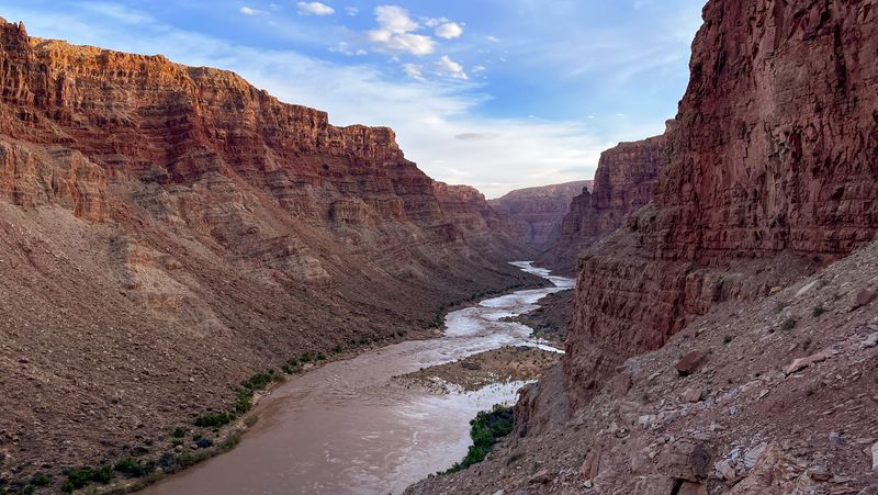
Cataract Canyon
Flatwater in, the Big Drops in the middle, no road out — the Canyonlands classic, by any of three launches.
Cataract Canyon is the classic multi-day river trip through the heart of Canyonlands. No road reaches the Confluence where the canyon begins, so every trip floats in — down the Colorado from Potash or down the Green through Stillwater Canyon. Below Spanish Bottom, the whitewater arrives quickly, building through the Big Drops before the river eases into Narrow Canyon and the take-out at North Wash. Your launch determines the mileage, days, and permits. Cataract Canyon itself is the constant.
Choose your route
-
Potash Launch classic
Potash Boat Ramp → North Wash / Dirty Devil Take Out
- Miles
- 95
- Days
- 3–6
- Sections
- 3
Forty-eight flatwater miles from Potash to the Confluence, then the whitewater. The standard launch.
Permit Canyonlands National Park Overnight River Permits
Peak runoff creates the classic big-water Cataract experience. Shoulder seasons reduce wave size but can increase flatwater drag and cold exposure.
-
Green River State Park Launch
Green River State Park → North Wash / Dirty Devil Take Out
- Miles
- 169
- Days
- 9–16
- Sections
- 4
The full Green-side line: 169 miles through Labyrinth and Stillwater before the Confluence and the Big Drops.
Permits Labyrinth Canyon permit · self-issued · Canyonlands National Park Overnight River Permits
Spring and fall are ideal — moderate temperatures, good flows, manageable Cataract water levels. Summer is brutal on the open flatwater (105°F+). High water in Cataract (May–June) raises the stakes at Big Drops significantly.
-
Mineral Bottom Launch
Mineral Bottom → North Wash / Dirty Devil Take Out
- Miles
- 101
- Days
- 5–10
- Sections
- 3
Launches on the Green at Mineral Bottom, skipping the 68-mile Labyrinth approach — the shortest float to the Confluence.
Permit Canyonlands National Park Overnight River Permits
Spring runoff delivers the classic big-water Cataract experience. Shoulder seasons trade wave scale for cooler temperatures and access to Mineral Bottom road in drier conditions. Summer heat on Stillwater can be brutal (100°F+); fall brings colder water and shorter days but clear light.
Potash Launch
Canonical Desert Maritime Cataract Canyon route beginning at Potash Boat Ramp, descending 48 miles to the Confluence, then 47 miles through Cataract and Narrow Canyon to the North Wash / Dirty Devil take-out zone.
- Distance
- 95 miles
- Typical days
- 4
The geography underneath
One recognizable trip, 3 named river sections. The trip has one name; the river carries you through more geography than that name reveals.
- Meander Canyon 48 mi approach
- Cataract Canyon 40 mi the journey
- Narrow Canyon 7.5 mi the journey
The journey
What the water is doing
Bands keyed to Colorado River at Potash, UT
-
5,000–10,000 cfs
Technical low water
current
Class III character with technical, rocky lines through the Big Drops. Pool-drop sequencing dominates; the long flatwater approach drags. Best for boulder-garden navigation and skill development.
-
10,000–20,000 cfs
Classic moderate
current
The sweet spot for experienced self-guided crews. Big Drops are powerful but scout-and-run with clean lines. Sandy beaches above water; hydraulics are well-defined and readable.
-
20,000–35,000 cfs
Big-water Class IV
current
Big-water Class IV. Hydraulics intensify, the sequence feels compressed, and pool recovery shrinks. Rewarding for crews with prior big-water experience; not a first run. (Class V territory begins at flood-stage flows above ~50,000 cfs.)
-
35,000–50,000 cfs
Big water
current
Pools start to wash out and beaches flood. Of the big water levels, this flow band is the most washed out. Now, North Seas & South Seas are starting 10-15', the Claw in Big Drop 2 is the major gotcha, Button Hole is washed. As always Rig to flip.
-
50,000–100,000 cfs
Serious big water
current
Most beaches are gone. North Seas, Mile Long South Seas top out around 20' and the Big Drops are in full flex. Expedition-grade above 50,000 cfs — commercial outfits shift tactics or cancel; private trips at that level only with a deep big-water experience.
-
100,000–130,000 cfs
Historical flood
current
Flood stage — the top of the record, peaking at 130,100 cfs in 1917. Not a runnable target; the Big Drops at their absolute limit.
Flow knowledge is owned by the Cataract Canyon section record — full flow spectrum and history there.
Access
- Put-in
- Potash Boat Ramp
- Take-out
- North Wash / Dirty Devil Take Out
Green River State Park Launch
The grand through-trip: 169 miles from Green River State Park through Labyrinth Canyon's quiet meanders, Stillwater Canyon's deep sandstone corridors, past the Confluence where the Green meets the Colorado, and through the full fury of Cataract Canyon's whitewater to the take-out at North Wash / Dirty Devil. This is one of the longest continuous river trips in the American West, combining 122 miles of flatwater on the Green with 47 miles of Class III-V rapids and transition water through Cataract and Narrow Canyon. The character shifts dramatically at the Confluence - from meditative desert silence to committed big water. Most groups take 10-14 days.
- Distance
- 169 miles
- Typical days
- 12
The geography underneath
One recognizable trip, 4 named river sections across 2 rivers. The trip has one name; the river carries you through more geography than that name reveals.
- Labyrinth Canyon 68 mi approach
- Stillwater Canyon 54 mi approach
- Cataract Canyon 40 mi the journey
- Narrow Canyon 7.5 mi the journey
The journey
What the water is doing
Bands keyed to Colorado River at Potash, UT
-
5,000–10,000 cfs
Technical low water
current
Class III character with technical, rocky lines through the Big Drops. Pool-drop sequencing dominates; the long flatwater approach drags. Best for boulder-garden navigation and skill development.
-
10,000–20,000 cfs
Classic moderate
current
The sweet spot for experienced self-guided crews. Big Drops are powerful but scout-and-run with clean lines. Sandy beaches above water; hydraulics are well-defined and readable.
-
20,000–35,000 cfs
Big-water Class IV
current
Big-water Class IV. Hydraulics intensify, the sequence feels compressed, and pool recovery shrinks. Rewarding for crews with prior big-water experience; not a first run. (Class V territory begins at flood-stage flows above ~50,000 cfs.)
-
35,000–50,000 cfs
Big water
current
Pools start to wash out and beaches flood. Of the big water levels, this flow band is the most washed out. Now, North Seas & South Seas are starting 10-15', the Claw in Big Drop 2 is the major gotcha, Button Hole is washed. As always Rig to flip.
-
50,000–100,000 cfs
Serious big water
current
Most beaches are gone. North Seas, Mile Long South Seas top out around 20' and the Big Drops are in full flex. Expedition-grade above 50,000 cfs — commercial outfits shift tactics or cancel; private trips at that level only with a deep big-water experience.
-
100,000–130,000 cfs
Historical flood
current
Flood stage — the top of the record, peaking at 130,100 cfs in 1917. Not a runnable target; the Big Drops at their absolute limit.
Flow knowledge is owned by the Cataract Canyon section record — full flow spectrum and history there.
Access
- Put-in
- Green River State Park
- Take-out
- North Wash / Dirty Devil Take Out
Mineral Bottom Launch
The Mineral Bottom launch skips the 68-mile Labyrinth Canyon approach and drops directly into Stillwater Canyon — the deep-sandstone reach where the Green River runs silent through Canyonlands' heart. From Mineral Bottom it is 54 miles of flatwater to the Confluence, then another 47 miles of Cataract Canyon and the Narrow Canyon / Lake Powell transition reach to the North Wash take-out. Total trip: 101 miles per NPS published mileage. This route is the standard alternative to the 169-mile Green River State Park launch — same Cataract experience, ~40 miles less flatwater, with the character shift where Stillwater's contemplative silence meets the Confluence and the combined Colorado begins to roar.
- Distance
- 101 miles
- Typical days
- 7
The geography underneath
One recognizable trip, 3 named river sections across 2 rivers. The trip has one name; the river carries you through more geography than that name reveals.
- Stillwater Canyon 54 mi approach
- Cataract Canyon 40 mi the journey
- Narrow Canyon 7.5 mi the journey
The journey
What the water is doing
Bands keyed to Colorado River at Potash, UT
-
5,000–10,000 cfs
Technical low water
current
Class III character with technical, rocky lines through the Big Drops. Pool-drop sequencing dominates; the long flatwater approach drags. Best for boulder-garden navigation and skill development.
-
10,000–20,000 cfs
Classic moderate
current
The sweet spot for experienced self-guided crews. Big Drops are powerful but scout-and-run with clean lines. Sandy beaches above water; hydraulics are well-defined and readable.
-
20,000–35,000 cfs
Big-water Class IV
current
Big-water Class IV. Hydraulics intensify, the sequence feels compressed, and pool recovery shrinks. Rewarding for crews with prior big-water experience; not a first run. (Class V territory begins at flood-stage flows above ~50,000 cfs.)
-
35,000–50,000 cfs
Big water
current
Pools start to wash out and beaches flood. Of the big water levels, this flow band is the most washed out. Now, North Seas & South Seas are starting 10-15', the Claw in Big Drop 2 is the major gotcha, Button Hole is washed. As always Rig to flip.
-
50,000–100,000 cfs
Serious big water
current
Most beaches are gone. North Seas, Mile Long South Seas top out around 20' and the Big Drops are in full flex. Expedition-grade above 50,000 cfs — commercial outfits shift tactics or cancel; private trips at that level only with a deep big-water experience.
-
100,000–130,000 cfs
Historical flood
current
Flood stage — the top of the record, peaking at 130,100 cfs in 1917. Not a runnable target; the Big Drops at their absolute limit.
Flow knowledge is owned by the Cataract Canyon section record — full flow spectrum and history there.
Access
- Put-in
- Mineral Bottom
- Take-out
- North Wash / Dirty Devil Take Out